zoom |
GPS Coordinates:
Latitude: 38.73343109051656 Longitude: -9.150259494781494
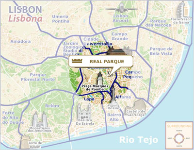
The city of Lisbon lies in the central coastal area of Portugal.
As the capital city, and also the biggest Portuguese city, Lisbon boasts
an international airport, making it extremely easy to arrive here from
any part of the world. The main national and international airline
companies fly from and into Lisbon.
For those travelling by train, Lisbon has two main train stations which
take in national and international train lines. The Gare do Oriente
station which lies, as the name suggests, in the western area of the
city (Parque das Nações) and Santa Apolónia station which is found near
the Alfama district in the historic centre of the city. |
To get to Lisbon by road, journeying from the south, the main access to
the capital is via the A2 SUL motorway. Coming from the north, access is
via A1 NORTE motorway and the A8 motorway. For those who prefer a more
leisurely-paced and economical journey, the network of national roads
which link Lisbon to the rest of the country can be used.
In its capacity as a port city, Lisbon is served by various
infrastructures ready to receive cruise ships and pleasure boats.
DISTANCES
City Center - 500m
Train Station - 500m
Bus Station - 50m
Lisbon International Airport - 7Km
Beaches - 15Km
Proximity services
Hospital / Health Centre - 30m
Bank - 50m
Pharmacy - 10m
Police Station - 100m
Post Office - 100m
Tourism Office - 800m
Public Phone - 50m
Bars and Discos - 1Km
Marina | Recreation Wharf - 2Km
Theme Parks | Aquatic - 1.5Km / 7Km
Historic Area - 1Km
Shopping Center El Corte Inglés - 100m
Casino Estoril - 20Km
Golf - 10Km |
|